
The Calder Woodland Way Day 1 – Brighouse to Mytholmroyd
Our walking companion, Emily, stood on the pavement with Jane and myself as we prepared to take our first steps. “Shall we pray?” she asked.
“Lord God, thank you that this is exactly the sort of weather that suits John and Jane. Please be with us, and especially John as he starts his challenge to raise the money he’s been sponsored for…”
It had seemed such a great idea. The cover of the trail leaflet looked temptingly innocuous. A gentle 23½ mile walk meandering along pretty footpaths serenaded by the sunlight dappled by leaves…easy strolls along the canal towpaths…all in all, a very pleasant way to raise money to repair our ailing church organ.
-o-O-o-
That, indeed, was how it began, with a peaceful mile along the towpath. Then up through Freeman’s Wood, descending the treacherous flagstones of Cat’s Steps to Andy the Milkman’s farm before climbing steadily into Cromwell Wood. Down and across Fairy Glen; a scramble up the bank to Boggart House which is s’posed to be haunted….You get the picture. Constantly changing scenery, much to notice and enjoy.
Then the rain began to fall. Ruefully mindful of Emily’s thanks for the weather, we donned our capes before descending through Binns Wood before climbing into Elland Park Wood. And here the instructions made no sense.
‘Carry straight on at a waymark post and wind through the much-excavated bumps at the heart of this oak woodland…’ There is no such post and no obvious path on which to ‘carry on’! Thank goodness we’d done our ‘getting lost’ beforehand in two different ways during our trial runs. I’d had a sore bum from slipping on a steep descent, after which our ignominious exit from the wrong part of the wood carried us on an unscheduled tour around Elland Crematorium…
After skirting the north of Elland, the route led us through a rocky woodland above the busy A629 towards Halifax, into the peaceful canal basin and back onto the south side of the valley. From there, we climbed on a pretty wooded path to North Dean Wood, walking high
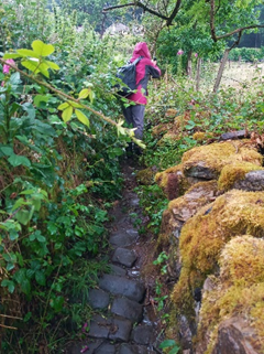
above a shear cliff. A well-concealed gate took us downhill to a farm called Upper Tinker Hey, after which we took a flagged path between stone walls that led over Maple Dean Clough (for non-Tykes, a clough is a steep-sided gorge with a stream). This track was enchanted; intensely beautiful, yet guarded by fierce brambles and nettles (pictured) through which we had to pick our sodden way to the aptly named village of Pickwood.
But worse was to come. A flight of steps leading towards Norland was stoutly defended by bracken and brambles

(pictured). Jane, from the front, announced that it was impassable, but somehow we soldiered on, trampling, slashing, flailing our arms until we emerged into the relative luxury of knee-deep grass.
The steep descent from Norland to Sowerby Bridge was much more straightforward, and we sat enjoying the hospitality of the Jubilee Refreshment Rooms . Jane reflected on a job well done before catching the train home, whilst Emily and I psyched ourselves up ready for the final leg.
-o-O-o-

The easiest two miles on the Way consisted of a very pleasant walk along the towpath from Sowerby Bridge to Luddenden Foot. After a short section on the main road, we turned northwards, rising above the valley, only to be plunged downwards on a footpath into the woods above Bearley Hall. The sun had taken Jane’s place as our companion, and shone its patterned light through the oak leaves, lighting up moss-covered rocks.
This was followed by the hardest mile, precariously negotiating jumbled rocks and tree roots on our descent to another woodland area criss-crossed with bike tracks and ramps. Emily said she could throttle whoever designed the route! With enormous relief we reached a waymark directing us onto the right path. The instructions talked about ‘a magical path climbing steeply through holly trees’ and that turned out to be accurate. A pretty descent through a beech wood, then through mixed undergrowth, led us down to another brambled flight of steps. At the bottom lay a track, then a footpath which led us around a homestead, before we forked southwards and downhill towards Mytholmroyd.
A drink at the pub seemed a natural way to finish our day’s walk. It had been hard earned! Whilst we marvelled at the beauty of our valley, we felt sad that so many of its footpaths have fallen into neglect, to the point that walkers may find the routes off-putting. How would Day 2 compare?

One thought on “The Vale of Tears?”