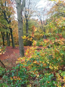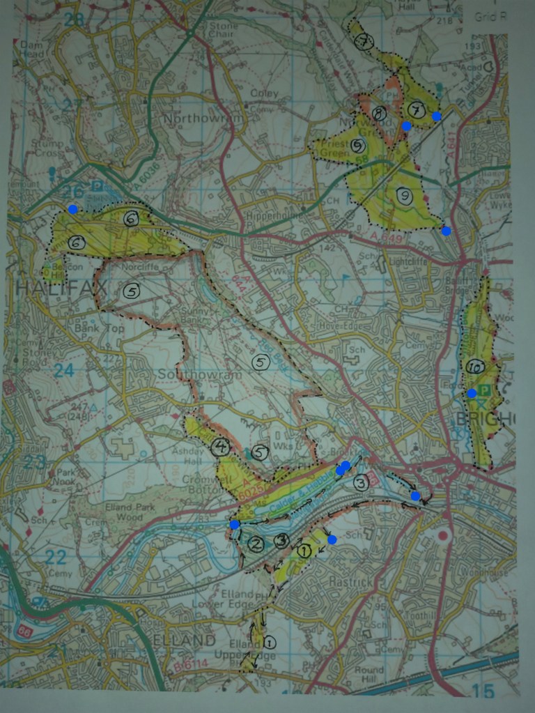
6. Shibden Park and Beacon Hill (3 miles) A pleasant park and a panoramic view of Halifax.
The walk starts at the car park above Shibden Hall, on Shibden Hall Road (no less!).
- Immediately across the road, go through a stile. Take a broad path heading uphill.
- At a fork in the path, go straight on (slightly uphill) and walk along the ridge. Enjoy the view!
- Turn Left into a walled path leading to a track. Here turn left. Follow round to the right.
- Walk downhill (Barraclough Lane) for half a mile. Continue as the track becomes a walled footpath, the aptly named Dark Lane(!), which finally bears left to become Badger Lane.
- Immediately after crossing a stream take a footpath Left. Continue through fields and a wood to Halifax Old Road. Cross over and, after 50 yards, turn Right onto Break Neck Lane.
- Continue under the railway, through a yard, to the A58 and turn Left.
- After 300 yards turn Left down a walked path into a wood leading to Shibden Park. Walk back through the grounds. Enjoy the paddle boats, train, the playground, the visitor centre with its café and – if you haven’t been – visit Gentleman Jack’s Shibden Hall – it’s a ‘must’!
7. Norwood Green and Judy Woods (about 2 miles) Walk across fields to a beautiful forest along well-defined paths.
Park on Station Road, Wyke. There’s a variety of walks and there are noticeboards to guide you. But here’s my favourite, mostly under tree cover which is great on a hot day.
- Park near the bottom of Station Road and walk on towards Norwood Green (600 yards)
- As you enter the village, several lanes meet including Rookes Lane which goes left downhill. Instead, take a track leading diagonally to the right and walk 200 yards to a style.
- Enter, then cross, the field to a squeeze style. Follow the path that leads straight ahead, around bushes and down to a gap in the wall of a track.
- Turn right along the track, across a bridge, then immediately through a gap on the Left, into the wood.
- A path leads alongside the stream. Don’t go uphill; instead, follow the waymarking posts.
- When the markers disappear, follow any path up through the wood and return via a path at the top. At a corner of the wood, turn Left. Follow a path leading diagonally through a field.
- Re-enter the wood. The path continues to a walled track, accessed through a gap.
- Cross the track, squeezing through a gate, to the broad footpath leading you through the wood back to Station Road. The wood contains a network of tracks (you can’t get lost) but If you bear right you will emerge close to where you’ve parked.
8. A Walk around Norwood Green (2 miles). Walk across fields; tracks, woodland
Park at the top of Rookes Lane as you enter the village. There’s a triangular memorial park opposite a playground alongside which there are usually parking spaces.
- Cross the road leading into the village from the East (Bradford) and – momentarily – turn left (away from Bradford). Take the track that leads diagonally right as in Walk 7.
- As in Walk 7, follow the footpath to the walled track. Go through the gap and turn Left.
- Follow the track uphill to the top of Norwood Green. Turn Right, then cross the road and walk across the bus turning circle. Turn Right along a path that leads behind an old chapel to a small green.
- Exit the green at the far end, into a wood, and follow the path around to the Left.
- Walk through the wood for half a mile. The footpath continues to Rookes Lane.
- Turn Left. After 100 yards take a footpath Right through a cultured lawn to a track.
- Turn Left and follow the track back to the memorial.
9. Bailiff Bridge – Lightcliffe – circular (4 miles). Walk across fields; tracks, woodland
The walk starts at the top of Victoria Road, Bailiff Bridge.
- Walk through a ginnel at the top of the road. Take a track leading Left.
- Cross a stile. Walk up a field and through a gate, then right along the end of a terrace.
- Cross a stile then through another field; cross a lane onto a track. After 300 yards take a footpath Right diagonally across a field to another stile. Turn Right onto a walled footpath.
- The path leads down under the railway, through a wood, across a stream, up to the A58.
- Cross CAREFULLY, turn Left and walk 200 yards. Sharp Left over a stile onto a walled path.
- Follow the path to Syke Lane. Turn Right; bear Right at a road junction then take a footpath Right through a door(!), leading downhill across open fields towards the end of a spur of woodland. Enter the wood and immediately cross a stile leading towards a copse.
- The path crosses a steam and leads up across stiles to Norwood Green Hill. Turn Right.
- After 10 yards take a track Right leading up into a wood, joining the path from Walk 8.
- Walk through the wood for half a mile. The footpath continues to Rookes Lane.
- Turn Left. After 100 yards take a footpath Right through a cultured lawn to a track.
- Turn Right (not Left) and follow the Calderdale Way across the A58 and back to the start.
10. Brighouse to Bailiff Bridge (4 miles). Parkland, tracks and footpaths through fields.
The walk starts at Wellholme Park car park, off Thornhills Beck Lane. We follow the Calderdale Way Northwards then return using the route of Brighouse Boundary Walk. This walk can be MUDDY!
- Walk through the park. At the far end, the paths on either side converge to a path leading uphill into the wood.
- Follow upwards to a bridleway, once a railway line. Turn Left along the bridleway.
- Follow the bridleway to where it bears left. Here, take a track up the bank leading to a stile.
- Join the Calderdale Way as it leads across a field, along Thornhills Lane to the hamlet of Thornhills, down via a track to Thornhills Beck Lane. The Way crosses to a footpath just above a house with a paddock, up through fields, and skirts Woolrow Farm. It descends via Woolrow Lane, passing under a bridge from the disused railway.
- Turn immediately left, following Brighouse Boundary Walk, along Low Lane that becomes a footpath leading to an estate. Walk downhill through the estate, descending by steps to a footpath leading through woodland to the beck.
- The Walk leads alongside (but not across) the beck, then through meadows to a wooded path. This emerges onto Thornhills Beck Lane. Turn Right to reach the car park.